Borrow a Councillor
Last updated:
Borrow a Councilor for a 30 minute meeting to discuss what's on your mind.
On shared unceded L̓il̓wat7úl and Sḵwx̱wú7mesh territory
Thank you to everyone who participated in the Concept engagement phase of the project. We had over 700 interactions with community members in this phase of the project, including our online tools and community open houses. Your contributions are essential in shaping the future of our community.
On December 16, 2025, we presented the Whistler Creek West Neighbourhood Plan to Council for endorsement. The Neighbourhood Plan establishes a vision for a vibrant neighbourhood and outlines the Land Use Concept and Plan Policies which will guide future change and growth. The Plan has been developed to support the Core Values and Big Ideas developed with the community in previous rounds of engagement.
The Resort Municipality of Whistler is developing a neighbourhood plan for Whistler Creek West.
The plan will develop a vision for the neighbourhood's future over the next 25 years, supporting diverse housing options, employment space, transportation, and community amenities. The plan will be used as the basis for any proposed land-use and development changes.
The neighbourhood plan and future revitalization efforts will focus on improving interconnectivity and pedestrian access through quality urban design while also increasing housing density and diversity, aiming to preserve Whistler Creek's unique character while accommodating future growth and needs.
Neighbourhood plans guide future development for an area, including the development standards, locations of public spaces, and transportation solutions. Neighbourhood plans are linked to the higher-level planning of the Official Community Plan and the regulatory detail of a zoning bylaw.
Whistler's Official Community Plan prioritizes Whistler Creek for a neighbourhood plan due to its potential for increased housing diversity and higher residential density. This vibrant area, which began as the base for Whistler Mountain and the first gondola in 1966, has evolved into a mixed-use community with residential options, shops, restaurants, and recreational facilities. Its proximity to the Creekside Village commercial hub, Highway 99, the core transit network, and major assets like Nita and Alpha Lakes enhance its appeal.

Click on the image to make bigger
Core Values are our beliefs and priorities: they define what we care about most and will guide the overall direction of the Plan.
The Core Values are:
The Big Ideas are high-level objectives to guide development of the Plan and are based on known challenges and opportunities in the Plan Area.
The Big Ideas are:
1. Diverse housing and increased density
Provide more residential housing types and options to meet the needs of a diverse population, particularly those who work in Whistler.
2. Repurpose and reimagine underused spaces
Develop vacant or underused lands to address gaps in the street and enhance neighbourhood vibrancy.
3. Improve connectivity of the area
Provide safe and efficient connections within the neighbourhood and to the surrounding area for preferred modes of travel.
4. Revitalize streetscape and public realm
Redesign the streetscape to be more pedestrian oriented, providing for year-round public activity and gathering space.
5. Maintain a distinct neighbourhood character
Maintain a unique sense of place that distinguishes Whistler Creek West from other areas through placemaking and design features.
6. Honour heritage and historical roots
Establishing a strong connection between the rich history of the neighbourhood to future development.
7. Support a thriving community
Fosters a vibrant mixed-use neighbourhood with a strong local ethos that supports a variety of businesses and amenities serving residents and visitors.
8. Connection to nature
Nurture a strong neighbourhood relationship with the lakes and mountains surrounding Whistler Creek West.
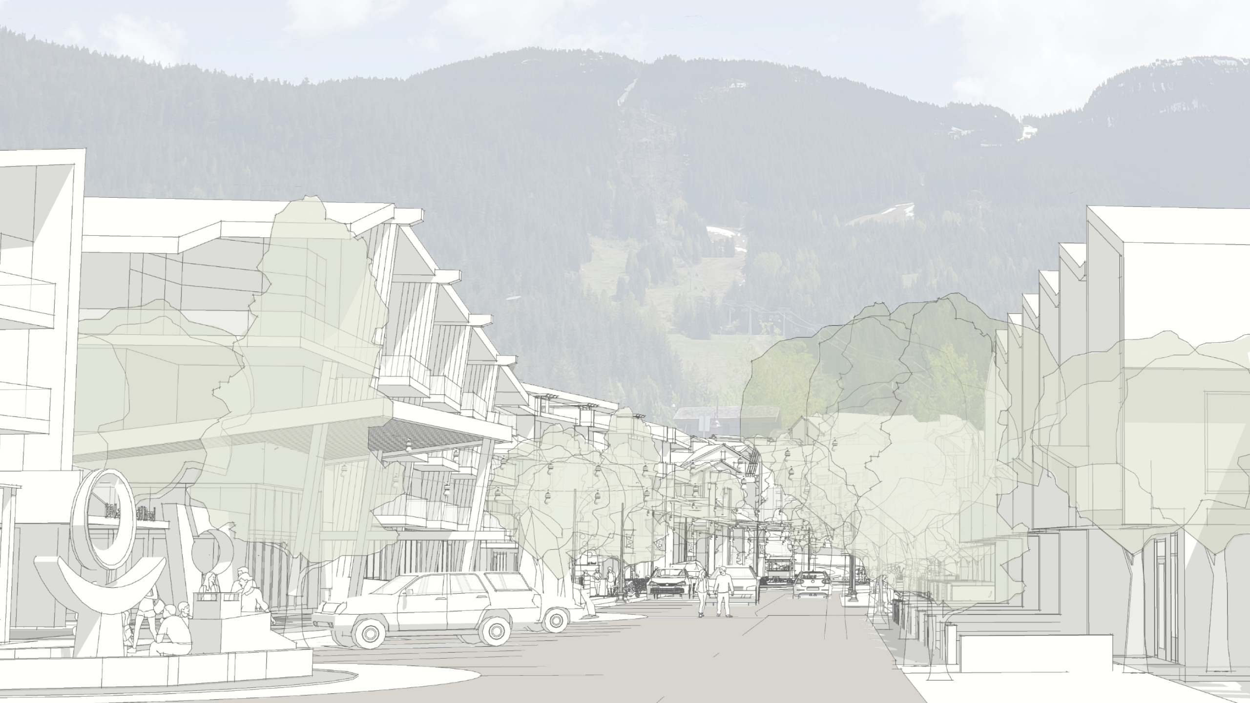
Possible view along Lake Placid Road towards Whistler Mountain if parcels are developed in line with the Plan.
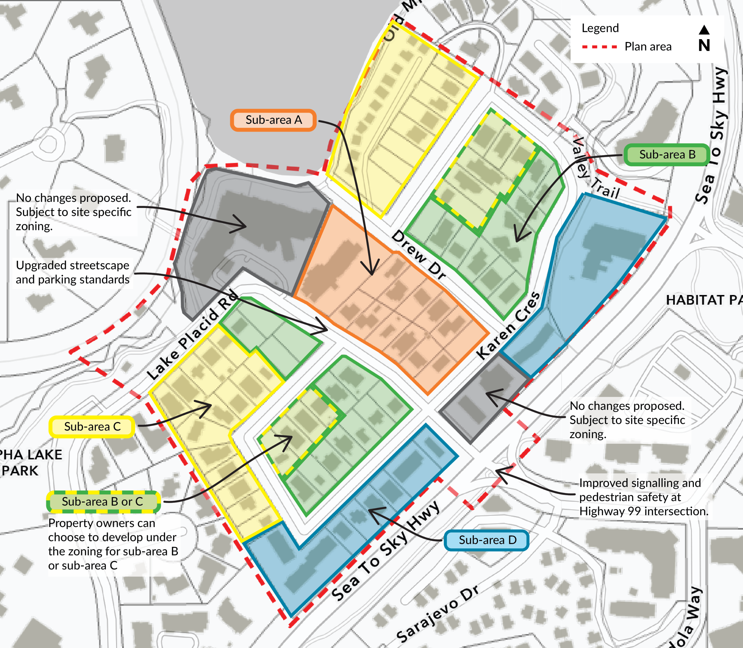
The WCW Plan vision is outlined through a land use concept divided into four sub-areas. Each sub-area describes the proposed uses, a range of storeys and density, and building types that will be used to inform the subsequent zoning amendment bylaw necessary to implement the WCW Plan. See pages 12 to 13 of the WCW Neighbourhood Plan for more detailed information on each of the sub-areas.
The WCW Plan policies have been developed to support the Core Values and Big Ideas to align the Plan's vision with direction from the OCP. Policies were developed to integrate with OCP Development Permit Area (DPA) guidelines, including the Whistler Creek DPA and Multi-Family DPA, which will continue to regulate form and character through specific guidelines for site design, building design and landscaping.
Please do not provide any personal information in your submitted feedback. If any is provided, it will be deleted upon receipt. All information collected by the Resort Municipality of Whistler (RMOW) for the purpose of providing comments on the Mapping Tool is authorized per s26(e) of the Freedom of Information and Protection of Privacy Act, and securely stored within Social PinPoint, on a Canadian-based server until project completion. If there are questions or concerns regarding the collection and/or use of personal information, please contact privacy@whistler.ca
| Name | Resort Municipality of Whistler |
|---|---|
| Phone | 604-932-5535 |
| info@whistler.ca | |
| In writing | Municipal Hall |
The Resort Municipality of Whistler is grateful to be on the shared, unceded territory of the Lil’wat People, known in their language as L̓il̓wat7úl, and the Squamish People, known in their language as Sḵwx̱wú7mesh. We respect and commit to a deep consideration of their history, culture, stewardship and voice.


