Background
The RMOW has completed a non-motorized Recreation Trails Strategy (RTS) that guides future decisions about how we develop, improve, access, fund, and manage non-motorized trails and trail amenities (e.g., staging areas, signage, etc.). The RTS does not specify the number, location, or types of trails. This will be the focus for a future and more detailed non-motorized Comprehensive Trails Plan.
The RTS reflects data compiled from many sources and contributors, and incorporates the latest ideas, community input, standards, and best practices on trail network development and management. The RTS is envisioned as a living document that will be adjusted as necessary over time to reflect evolving opportunities, challenges, and priorities.
Project objectives
- Achieve shared high-level direction related to:
- Non-motorized trail and trail-related amenity development, improvements, access, funding and management, including approaches, practices and responsibilities
- Potential areas for future trail connectedness, development and improvement
- Emerging trail user types and needs
- Non-motorized trail-related challenges that have emerged in recent years
- Enhance community understanding of the breadth and complexity of trail management, and the associated financial implications
- Identify reliable and consistent funding sources for annual trail maintenance
- Develop a clear, easy to use Recreation Trails Strategy document that articulates shared trail-related direction and integrates all key trail-related topics together in one place
- Establish the groundwork for a future and more locational specific Comprehensive Trails Plan
Project deliverables
The Strategy produced these documents to support future planning:
- Evolving Terminology
- Environmentally Responsible Trail Planning Guidelines
- Trail Access and Staging Guidelines
- Trail Review and Approval Process Flowcharts
- Trail network Areas Suitability Analysis and Recommendations
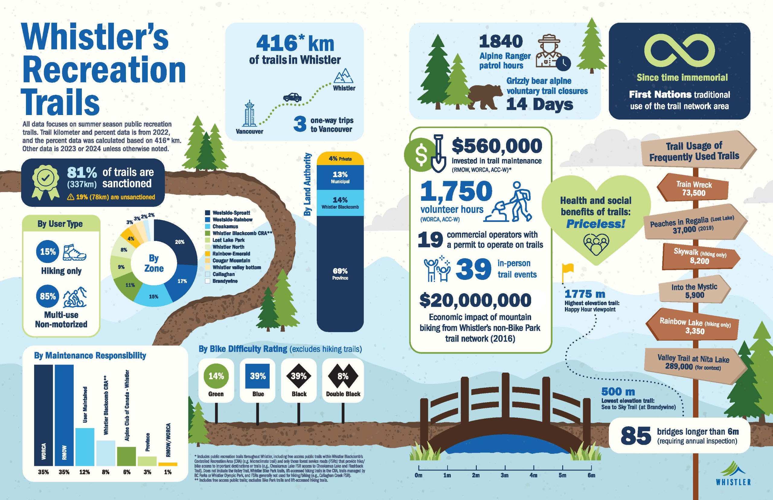
- Whistler’s Recreation Trails Infographic
- Maps
Recreation Trails Infographic
Engagement
Three phases of community engagement occurred, as well as detailed meetings with trail user groups including WORCA and the Alpine Club of Canada Whistler Chapter.
Referrals and discussion with the Líl̓wat Nation and Sḵwx̱wú7mesh Úxwumixw occurred throughout the project.


